Mae Ping National Park “beautiful forests and wonderful for birdwatching”

Mae Ping National Park covers Doi Tao District, Chiang Mai province; Li District, Lam Phun Province; and Sam Ngao District, Tak Province. It is fertile forest, which riches of plants and animals. At 1,003.75 km2, the rugged mountain range and rivers made fantastic scenic, especially the upper part of Bhumipol Dam that suit for recreation.
Geography
General topography is steeply mountain range with average high of 900 meters above sea level. There are many stream headwaters along the hill for example Huai Mae Had, Huai Mae Ko, Huai Pong Ka, Huai Muang, Huai Khun Maen and Huai Krai. All are branches of Mae Ping River.
The lake area covers Doi Tao District, Chiang Mai. Water flow southward to Bhumipol Dam in Amphur Sam Ngao, Tak for 150 kilometers. The widest point, with 6 kilometers is called “Bo Lom” and “Hauy Phra Bat”.

Climate
There are 3 main seasons same as other provinces in northern Thailand. There are rainy, cold and hot seasons but it may different from the area nearby dues to the large territory.
Flora and Fauna
80% of the park total area is shading leaves forest especially on the hill and less than 1,000 meters above sea level high elevation. And another 20% forest is moist evergreen forest. Teak, Shorea obtusa, Shorea siamensis, Dipterocarpus obtusifollus, Afzelia xylocarpa and Pterocarpus macrocarpus are found as dominant trees.
Wild life, which are found here they are; barking deer, wild pig, serow, gallus gallus, goral, fishing cat, asiatic black beer, small indian civet, macaque, langur and gibbon. Including, birds and fishes.
Tourist Attractions at Mae Ping National Park

Kaeng Koh : Kaeng Koh is a beautiful lake, suit for recreation so the park provided floating raft houses there. Kaeng Koh Raft house is the middle of Bhumipol Dam, from this point, you can take a marine trip to admire beautiful scenic. There are also many tourist places such as Um Pae Waterfall, Um Pad Waterfall, Pha (Cliff) Tao, Pha Phra Non, Kaeng Soi, Phra Bat Bo Lom and Bhumipol Dam.

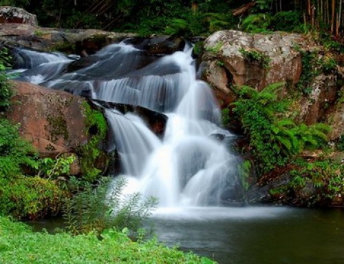
Koh Luang Waterfall: Koh Luang Waterfall: located 20 kilometers from the Headquarters and you can reach by car. The limestone waterfall is well known among Lam Phun people and province nearby. There are 7 levels with different heights.


Bird watching: Due to its broad altitudes, high elevation and cool climate, the park supports a large number of bird species.
Yang Wee Cave: lied in Li District, Lam Phun. It is limestone cave, comprising fascinating stalactite and stalagmite.
Thung Kik: Thung Kik is the wide grassy land in the east of the park. The plateau is covered by grass and is a habitat for barking deers, sambar deers, rabbits and gallus’s.

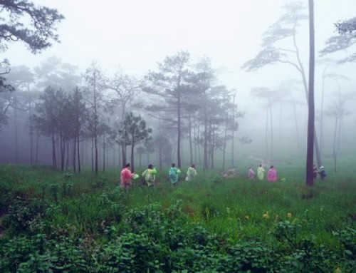
Trekking: Visitors can hike through the fertile forest and do study on wildlife and plants. There are many interesting spots such as waterfalls, caves, lakes, grassland, view points in the park.
Phra Bat Yang Wee Pine Forest: Encompassed hill pine forest-was called “Pa Phra Bat Yang Wee”. The forest is fertile and very beautiful, suit for recreation. Visitor can reach by trekking and enjoy camping there.
Facilities
Mae Ping national park provides bungalows at the headquarters and floating raft houses at Kaeng Kor lake ranger station.
Contact address
Mae Ping National Park
P.O.Box 18, Amphur Li, Lamphun Province 51110
Tel: 053 – 519 031
How to get there
From Lam Phun take the highway no. 106 to the south for about 80 km to a small town called “Li”. From there take the highway no. 1087 (Li – Ko). Between km marks 20 and 21 you will see the park’s headquarters. By river the park can be reached from either Doi Tao reservoir (sailing downstream on Mae Ping river) or from Bhumiphon dam (sailing upstream on Mae Ping river) another way for more comfortable in your trip, you can book the car rental with driver for your group.
Opening hours and Entrance fee : Opens daily from 8 am until 4.30 pm. Admission fee : Thai adult 50 THB children 10 THB / foreigner adult 100 THB children 50 THB.
Note : Not accessible for wheelchair user
Our services :

Mae Ping National Park Map


Leave A Comment