Discover the Natural Beauty of Doi Wiang Pha National Park

Doi Wiang Pha National Park covers and area of 583 square kilometres in Amphoe Chai Prakan and Fang, Chiang Mai province and Amphoe Mae Suai, Chiang Rai province. The National Park is in the consideration process of being one of the Thailand’s national park.
Geography
The National Park features rugged mountain range. “Doi Wiang Pha” is the highest peak with 1.834 metres high.
Climate
Rainy season is from May to October. Summer is from March to Apr! and winter season is November to February, which is proper for visiting.


Flora and fauna
Mixed deciduous forest, deciduous dipterocarp forest and evergreen forest blankets the National Park with various plants such as Tectona grands, Dipterocaipus alatus, Pterocarpus macrocarpus, Mechelia floribunda, Pinus merkusii including various kinds of Moss, Fern and Orchids. The National Park is home to wildlife such as Common Muntjak, Wild Boar, Serow, Porcupine, Siamese Hare, Palm Civet, Treeshrew, Macaque and Squirrel, as well as various kinds of birds such as White-rumped Shama, Dove, Hawk and Red Junglefowl.
Attractions
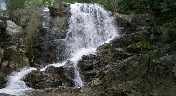
Huai Sai Khao Waterfall
♦ Huai Sai Khao Waterfall is a small but picturesque waterfall located within the Doi Wiang Pha National Park. It is only 300 meters away from the National Park Office and can be easily accessed by visitors. The waterfall consists of three levels of cascading water that originate from Huai Sai Khao, adding to the natural beauty of the surrounding area. Visitors can enjoy the refreshing cool waters and natural scenery, making it a great spot for a picnic or a short hike. With its tranquil atmosphere and scenic surroundings.
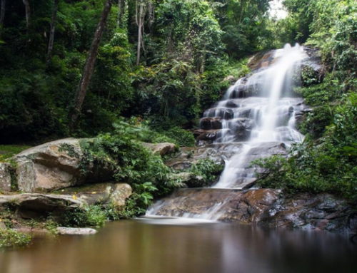
♦ Doi Wiang Pha Waterfall is a medium-sized waterfall located about 8 kilometers from the National Park Office. It stands at 18 meters tall and is a popular destination for visitors seeking a refreshing swim or a peaceful picnic in nature. The waterfall is surrounded by lush greenery and provides a tranquil atmosphere for relaxation and enjoyment.

Mae Fang Luang Waterfall
♦ Mae Fang Luang Waterfall is a medium-sized waterfall with a height of 10 meters. The waterfall is surrounded by lush greenery and is a perfect spot for a refreshing dip in the cool waters. Visitors can enjoy the picturesque natural scenery and take a relaxing break amidst nature. The trail leading to the waterfall is an easy hike and suitable for all ages.

Doi Wiang Pha Viewpoint
♦ Doi Wiang Pha Viewpoint, offers visitors stunning natural scenery and breathtaking views of the surrounding landscape. From this hilltop vantage point, visitors can enjoy panoramic views of the lush forests, rolling hills, and verdant valleys that make up this beautiful region of Northern Thailand. The viewpoint is easily accessible by car or by foot, and is a popular destination for nature enthusiasts and photographers seeking to capture the stunning vistas of Doi Wiang Pha. Visitors can also enjoy a range of outdoor activities in the surrounding area, including hiking, camping, and birdwatching.

Doi Wiang Pha National Park Map


Leave A Comment